| dc.contributor | Ecosystems Division | en_US |
| dc.contributor.author | United Nations Environment Programme | en_US |
| dc.coverage.spatial | State of Palestine | en_US |
| dc.date.accessioned | 2025-05-19T07:43:25Z | |
| dc.date.available | 2025-05-19T07:43:25Z | |
| dc.date.issued | 2025-05 | |
| dc.date.submitted | 2025-05 | |
| dc.identifier.uri | https://wedocs.unep.org/20.500.11822/47574 | |
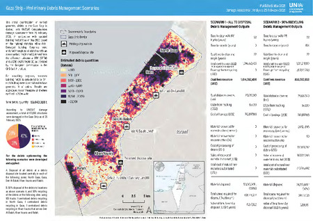
| dc.description | This initial quantification of conflict generated debris in the Gaza Strip is derived from UNOSAT Comprehensive Damage Assessment from 25 February 2025, in conjunction with updated building footprint as of May 2023 based on the national statistical office data. Damaged building footprints were enriched through zonal statistics with an above surface height model, derived from the difference between a DTM (SRTM) and a DSM (ALOS World 3D) as provided by the European Commission in the GHS-Built H product. | en_US |
| dc.format | pdf | en_US |
| dc.language | English | en_US |
| dc.subject | damage assessment | en_US |
| dc.subject | waste | en_US |
| dc.title | Gaza Strip: Preliminary Debris Management Scenarios - Damage Assessment Analysis: 25 February 2025 | en_US |
| dc.type | Factsheets, Infographics and Brochures | en_US |
| wd.identifier.sdg | SDG 3 - Good Health and Well-Being | en_US |
| wd.topics | Chemicals and Pollution Action | en_US |
| wd.identifier.pagesnumber | 1 p. | en_US |