| dc.contributor | Science Division | en_US |
| dc.contributor.author | United Nations Environment Programme | en_US |
| dc.coverage.spatial | Brazil | en_US |
| dc.date.accessioned | 2022-10-17T05:14:35Z | |
| dc.date.available | 2022-10-17T05:14:35Z | |
| dc.date.issued | 2011 | |
| dc.identifier.uri | https://wedocs.unep.org/20.500.11822/40834 | |
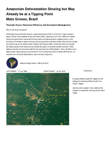
| dc.description | At the beginning of the 20th century, roughly 80 percent of the 5 million km2 "Legal Amazon" region of Brazil was forested (Kirby and others 2006). Highways built in the 1950s and 1960s, along with government incentives for colonization and development, created a boom in the conversion of forests to cattle ranching and farming (Kirby and others 2006). Much of this change occurred along an arc at the southern edge of the Amazon Basin where the newly built roads facilitated access to the forest and connected the region to markets outside the forest. | en_US |
| dc.format | Text | en_US |
| dc.language | English | en_US |
| dc.relation.ispartof | UNEP Global Environmental Alert Service (GEAS) | en_US |
| dc.rights | Public | en_US |
| dc.subject | deforestation | en_US |
| dc.subject | Brazil | en_US |
| dc.subject | forest | en_US |
| dc.title | Amazonian Deforestation Slowing but May Already be at a Tipping Point Mato Grosso, Brazil - UNEP Global Environmental Alert Service (GEAS) 2011 | en_US |