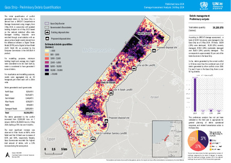
Gaza Strip - Preliminary Debris Quantification: Damage Assessment Analysis 3rd May 2024

Date
2024-06Author
United Nations Environment Programme
United Nations Human Settlements Programme
Citation Tool
Bibliographic Managers
RT Generic T1 Gaza Strip - Preliminary Debris Quantification: Damage Assessment Analysis 3rd May 2024 A1 United Nations Environment Programme, United Nations Human Settlements Programme YR 2024-06 LK https://wedocs.unep.org/20.500.11822/46575 PB AB TY - GEN T1 - Gaza Strip - Preliminary Debris Quantification: Damage Assessment Analysis 3rd May 2024 AU - United Nations Environment Programme, United Nations Human Settlements Programme Y1 - 2024-06 UR - https://wedocs.unep.org/20.500.11822/46575 PB - AB - @misc{20.500.11822_46575 author = {United Nations Environment Programme, United Nations Human Settlements Programme}, title = {Gaza Strip - Preliminary Debris Quantification: Damage Assessment Analysis 3rd May 2024}, year = {2024-06}, abstract = {}, url = {https://wedocs.unep.org/20.500.11822/46575} } @misc{20.500.11822_46575 author = {United Nations Environment Programme, United Nations Human Settlements Programme}, title = {Gaza Strip - Preliminary Debris Quantification: Damage Assessment Analysis 3rd May 2024}, year = {2024-06}, abstract = {}, url = {https://wedocs.unep.org/20.500.11822/46575} } TY - GEN T1 - Gaza Strip - Preliminary Debris Quantification: Damage Assessment Analysis 3rd May 2024 AU - United Nations Environment ProgrammeUnited Nations Environment Programme, United Nations Human Settlements Programme UR - https://wedocs.unep.org/20.500.11822/46575 PB - AB -View/Open
Item Statistics
Display item statisticsMetadata
Show full item recordDescription
This initial quantification of conflict generated debris in the Gaza Strip is derived from a UNOSAT Comprehensive Damage Assessment using imagery from 3 May 2024, in conjunction with updated building footprint as of May 2023 based on the national statistical office data. Damaged building footprints were enriched through zonal statistics with an above surface height model, derived from the difference between a Digital Terrain Model (SRTM) and a Digital Surface Model (ALOS World 3D) as provided by the European Commission in the GHS-Built H product.
Collections
Document Viewer
To read more, scroll down below.

